SOSS: A sustainability license for our open source projects
A license fee for open source? No reason to panic: Our projects MapProxy, Imposm and Magnacarto are open source and they will stay open source. You can use them in commercial projects, you can read, modify and extend the source code and you can install our software on as many servers as you like. This won't change and you won't have to pay license fees for that.
However, we are now offering you to purchase a Sustainability-Open-Source-Software License – SOSS License – for our open source projects.
The SOSS License is a sustainability license with the goal to fund the long-term development of our open source projects.
Your benefits from a SOSS License
Technology and standards are evolving and only a project that gets continuous development can be a powerful solution in the future. However, maintenance and development of open source costs money. Therefore we are asking users of our software to purchase a commercial license to help funding this long-term development.
With the license you will make sure that the software you are relying on gets active maintenance and new development: Bugs get quicker resolved, with frequent releases. New features that will keep you whole system up-to-date.
But that's not all. As a licensee you will also be able to steer the future development. You can choose multiple points where you want to see new development. The more licensees support a single point, the faster the development will proceed.
You should consider purchasing a SOSS License
- if our software makes your live easier
- if our software saves your company or agency time and money or
- if our software is part of your business
and of course, if you have an interest in the future development of our software.
We hope that you are now interested in our sustainability licenses. You will find more information on our homepage.
Additional links
Magnacarto: Convert CartoCSS to MapServer and Mapnik
We are pleased to announce the first release of Magnacarto, a new open source tool that converts CartoCSS files to map styling for Mapnik and MapServer.
CartoCSS allows you to create complex map styles with a CSS like syntax. The CSS syntax and features like variables and attachments help you to manage complex styles: A few hundred lines of CartoCSS can result in a few thousand lines of MapServer stylings.
Magnacarto is a command line tool and we have binaries for Windows, Linux and Mac OS. Detailed informations and a download link for the binareis you will find on Github.
Magnacarto App
We are also working on a web-frontend for magnacarto that shows you an interactive map with the final styling. It supports multiple views of your map and reloads of the maps automatically as soon as you make changes to the styling.
Additional links
From our German blog
Neue MapProxy Version 1.8.0 veröffentlicht
Wir freuen uns das Release der neuen MapProxy Version bekanntzugeben. Die neue Version steht unter http://pypi.python.org/pypi/MapProxy zum Download bereit.
Python 3 & ... Weiterlesen... →
Web-based configuration for MapProxy
We are pleased to announce the development of MapProxy WebConf.
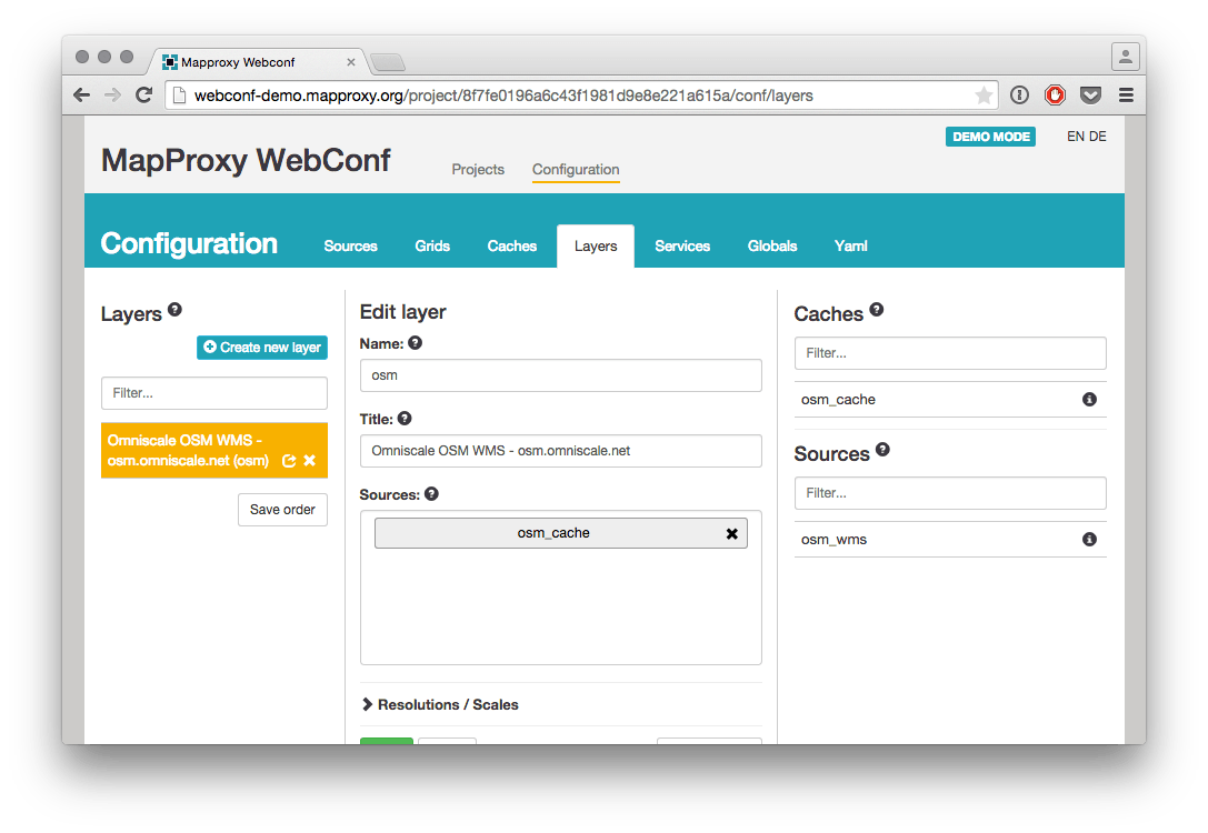
MapProxy WebConf is a small web-based configuration tool for MapProxy. The current implementation of MapProxy WebConf is able to create new configurations and to save them as .yaml files. It already allows easy configuration with drag & drop. Most MapProxy options are available in WebConf and you can edit missing options with the edit manually mode.
MapProxy WebConf is Open Source and released under the Apache Software License 2.0.
The current version shows what is possible with a sophisticated configuration tool. The integration in MapProxy, the configuration and management of seeding-tasks and the loading of existing configurations are a few larger open issues where we are looking for contributions in form of feedback, code or sponsoring.
Feel free to test the tool on our on-line demo: http://webconf-demo.mapproxy.org or check out the Source Code on GitHub
Additional links
Use OpenStreetMap everywhere
Thanks to Google Maps, OpenStreetMap and the like, it was never so easy to access world wide maps and to add them to a web application. But special map services are required as soon as you want to integrate these maps into desktop applications or if you need them to be combined with external spatial data.
We offer such map services based on OpenStreetMap since 2009: For web applications like the German Broadband Atlas, as background maps in network and utility management or for location planning.
We are now combining our long-time experience with these map services in our new platform maps.omniscale.com. With this platform we offer you a convenient way to get immediate access to our map services. This blog post highlights a few features of maps.omniscale.com.
- Full WMS support for desktop GIS
- Tile services optimized for web applications
- Use any projection
- High quality for printing
- High speed and reliability
- Live updated maps
- Ready to use
- Convenient and cost-efficient
High speed and flexible maps
We have a strong focus on the speed of our map services. Our maps are rendered live, within sub-seconds, in all map scales.
You can use our maps in desktop as well as web applications. Both have a lot in common, but there a few differences in the detail.
Desktop applications
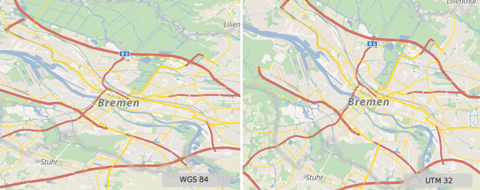
For desktop applications we offer our services as a WMS. All desktop GIS and most CAD, planning and analysis applications support the WMS standard to integrate external maps. With WMS you can flexible request our maps in the coordinate system of your business data.
A list of all supported coordinate systems of our OpenStreetMap WMS can be found here.
Web GIS
Maps are typically embedded in web applications as tiles. Besides WMS access we also support tiled access with our services as well.
Tiles need to be aligned on a fixed tile grid with a predefined projection and a fixed set of map scales. Most web map applications are using a tile grid that is compatible with Google Maps and OpenStreetMap. But other coordinate systems and map scales are often a requirement as soon as the base map needs to be combined with your business data.
Our tile service allows you to use projections and map scales that suites your data. Define any tile grid in your application – our tile service automatically adapts to the right zoom levels and map scale.
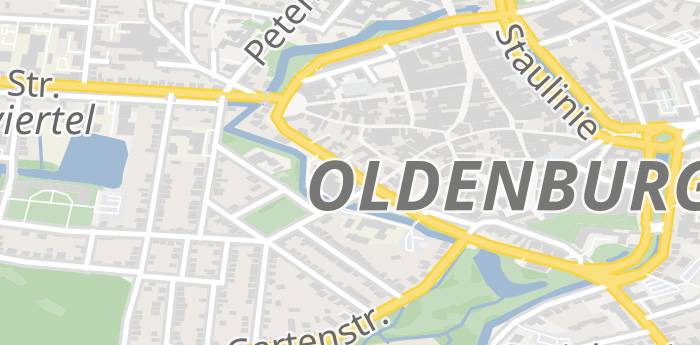
Clean map design and separate layers
OpenStreetMap is a vast data source. We optimized our maps to be clear and to avoid any confusions. Uninteresting details like restaurants are noise in background maps and are not show on our maps.
You also have the possibility to choose which layers should be displayed on the map. Create a map without land use and buildings for example, to overlay it on aerial images.
Besides a colored map style we also offer our maps in an unobtrusive gray-scale style.
You can see the maps in our on-line demo. You can create a free account for a test in your desktop GIS.
What is behind the map?
With the GetFeatureInformation function from the WMS standard you can request detailed information with a single click. Get information about the land use of a single parcel for example.
This feature is supported by most desktop GIS applications. All objects are also linked back to openstreetmap.org to show you the history of each element.
Printable maps
Sometimes it's still required to print maps. Our service allows to create high resolution maps with 300 DPI to prevent blurred and pixelated maps.
The data
We use OpenStreetMap data as the source for all of our map services. OpenStreetMap grows day by day and the data gets improved continuously.
We keep our dataset in-sync with the official OpenStreetMap dataset and render all maps on-the-fly so that you can immediately benefit from all changes to OpenStreetMap.
Immediately available and free for evaluation
We developed an on-line portal to manage the map services. You can create new accounts for our WMS and tile services 24/7. After free registration you get access to our OpenStreetMap WMS for desktop applications for 14 days.
Access to our map services for web applications require an API-key which is also free for evaluation. Prices for our map services start at 25€ per month.
Additional links
From our German blog
Rückblick FOSSGIS Konferenz 2015
Die diesjährige FOSSGIS-Konferenz fand vom 11. bis zum 13. März 2015 an der Universität in Münster statt. Das umfangreiche Programm der Konferenz lockte über 460 interessierte Teilnehmer an.
Vor der offiziellen Eröffnung gab es in diesem Jahr wieder ... Weiterlesen... →
Development of a modern city map based on official data and OpenStreetMap
In 2013 Omniscale developed an attractive city map for the German state of Mecklenburg-West Pomerania .
A special feature for this map is that official data from the public administration as well as data from the OpenStreetMap project were processed and displayed on a single map.
At the beginning of this year the city map was updated. In addition a new web application, based on the OpenLayers 3 library, was developed.
The data
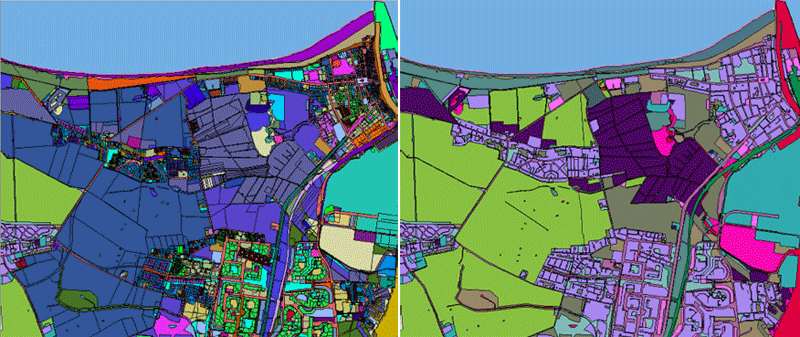
To display official data from the public administration combined with data from the OpenStreetMap project the data has to be processed and simplified. The data was transformed into the coordinate system UTM 32 and was imported into a PostGIS database
OpenStreetMap
For the import of the OpenStreetMap data the open source software Imposm was used. Imposm is designed to create databases that are optimized for rendering services.
From the OpenStreetMap project all streets, areas, building labels, all water areas and points of interest (POIs) were imported. POIs are not displayed on the map by default, but they can be selected and printed in the web application by the user.
Imposm can limit imported geometries. Geometries outside the polygon were deleted or truncated, in this case the data from Mecklenburg-West Pomerania were used.
During the import Imposm optimizes the data for rendering. Imposm creates generalized tables with lower spatial resolutions automatically: This is perfect for rendering large road networks in low resolutions.
Data from public administration
From the data of the public administration all buildings with house numbers, the land use and the borders were used.
During the import the data is optimised as well. In this case, the number of polygons were drastically reduced. Areas with the same type of use are rendered in the same color and so these areas can be combined and simplified. With this optimization the number of objects to draw, and therefore the time it takes to render a map, has been reduced.
Updating the data
The system was developed to allow an update of the official data by changing the official source shapefiles. An import script performs all other import and optimization steps automatically.
For updating the OpenStreetMap data the open source software Osmosis with diff-support was used. Diffs are small compressed XML files that contains the changes in the OpenStreetMap data over some period in time. After updating the OSM file with the diff, Imposm was used to import the data in the database again. Future iterations of the project can avoid the extra step with Osmosis by use of the new Imposm 3 release.
The Map
For the server-based map rendering the open source software MapServer was used. Besides the technical realization, the focus was also on the individual design of the maps. The design was adapted to the requirements of the customer.
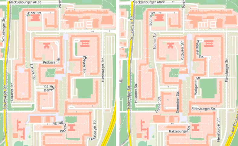
On the first development iteration MapServer 6 was used. Particular emphasis was laid on the on the labelling of streets. The aim for the city map was to label as many streets as possible. Because of this, a lot of labels were placed often in curved or ring-shaped streets. Thus a lot of labels were hard to read.
In the course of this project the labeling of MapServer was improved. MapServer now moves labels away from sharp corners until they are readable. The following image show labels rendered with MapServer 6 and with a development version of MapServer 7.
The city map service is also provided by the open source software MapProxy. MapProxy accelerates the map service and provides a WMS and a tile service. MapProxy is also responsible for updating of the tiles when the OSM data changed during a new import.
Application
To reach people you need more than a map. Therefore Omniscale developed a new web application which uses the city map and adds additional functions.
The application based on OpenLayers 3 combined with AngularJS. The complete application was published as open source project Anol.
On the FOSSGIS-conference, the largest german-language conference for Free and Open Source Software for GIS and Free Geodata, we will introduce Anol for the first time. Afterwards we will write an article in this blog an introduce Anol in detail.
Additionally, the application provides POIs. The user can display different POIs of a specific category and personal interests on the map.
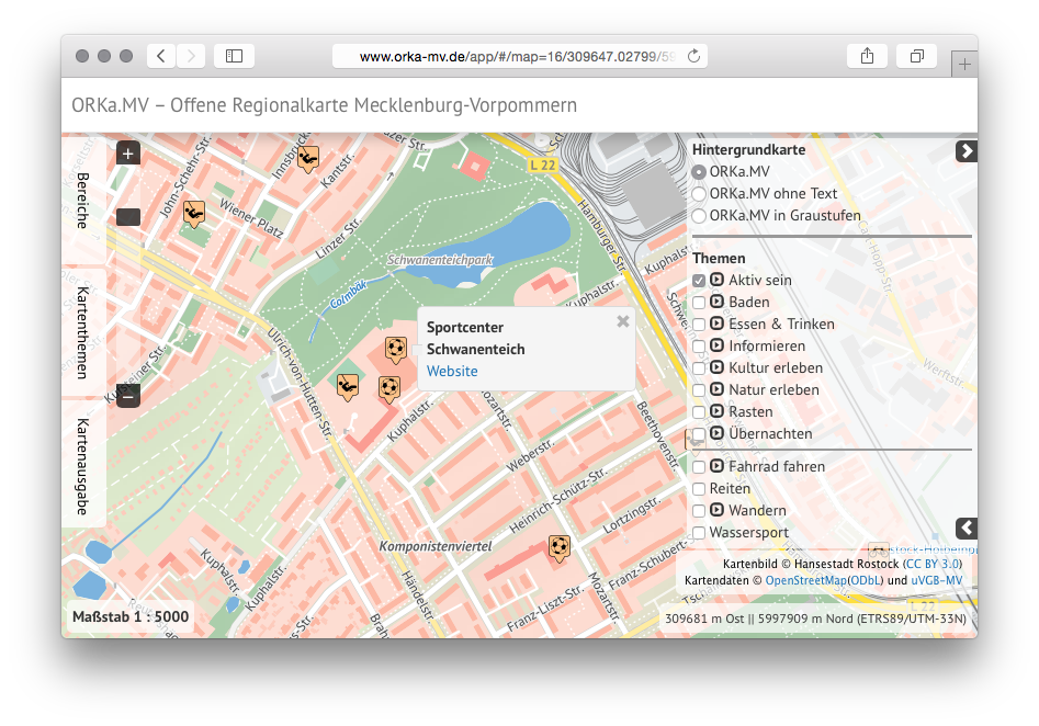
The application and the city map service were also extended by a print service. Ominiscale's print service makes it possible for the user to download a map in a high quality. The maps are available for download in various image formats (PNG, PDF, SVG, etc.) and with a resolution of 300 DPI.
In addition to the download of the maps, the application allows to create a search grid including a street index for the selected region. This function is typically known from city maps. The search grid is displayed on the map and all streets in the index can be easily located on the map with the reference to the corresponding grid cell.
Additional links
From our German blog
FOSSGIS Konferenz 2015
Vom 11. bis zum 13. März 2015 findet dieses Jahr die FOSSGIS-Konferenz an der Universität Münster statt. Die FOSSGIS-Konferenz ist die größte deutschsprachige Anwenderkonferenz für freie Geo-Software und freie ... Weiterlesen... →