Use OpenStreetMap everywhere
Thanks to Google Maps, OpenStreetMap and the like, it was never so easy to access world wide maps and to add them to a web application. But special map services are required as soon as you want to integrate these maps into desktop applications or if you need them to be combined with external spatial data.
We offer such map services based on OpenStreetMap since 2009: For web applications like the German Broadband Atlas, as background maps in network and utility management or for location planning.
We are now combining our long-time experience with these map services in our new platform maps.omniscale.com. With this platform we offer you a convenient way to get immediate access to our map services. This blog post highlights a few features of maps.omniscale.com.
- Full WMS support for desktop GIS
- Tile services optimized for web applications
- Use any projection
- High quality for printing
- High speed and reliability
- Live updated maps
- Ready to use
- Convenient and cost-efficient
High speed and flexible maps
We have a strong focus on the speed of our map services. Our maps are rendered live, within sub-seconds, in all map scales.
You can use our maps in desktop as well as web applications. Both have a lot in common, but there a few differences in the detail.
Desktop applications
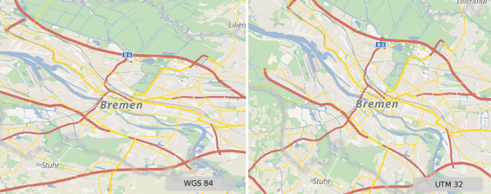
For desktop applications we offer our services as a WMS. All desktop GIS and most CAD, planning and analysis applications support the WMS standard to integrate external maps. With WMS you can flexible request our maps in the coordinate system of your business data.
A list of all supported coordinate systems of our OpenStreetMap WMS can be found here.
Web GIS
Maps are typically embedded in web applications as tiles. Besides WMS access we also support tiled access with our services as well.
Tiles need to be aligned on a fixed tile grid with a predefined projection and a fixed set of map scales. Most web map applications are using a tile grid that is compatible with Google Maps and OpenStreetMap. But other coordinate systems and map scales are often a requirement as soon as the base map needs to be combined with your business data.
Our tile service allows you to use projections and map scales that suites your data. Define any tile grid in your application – our tile service automatically adapts to the right zoom levels and map scale.

Clean map design and separate layers
OpenStreetMap is a vast data source. We optimized our maps to be clear and to avoid any confusions. Uninteresting details like restaurants are noise in background maps and are not show on our maps.
You also have the possibility to choose which layers should be displayed on the map. Create a map without land use and buildings for example, to overlay it on aerial images.
Besides a colored map style we also offer our maps in an unobtrusive gray-scale style.
You can see the maps in our on-line demo. You can create a free account for a test in your desktop GIS.

What is behind the map?
With the GetFeatureInformation function from the WMS standard you can request detailed information with a single click. Get information about the land use of a single parcel for example.
This feature is supported by most desktop GIS applications. All objects are also linked back to openstreetmap.org to show you the history of each element.
Printable maps
Sometimes it's still required to print maps. Our service allows to create high resolution maps with 300 DPI to prevent blurred and pixelated maps.

The data
We use OpenStreetMap data as the source for all of our map services. OpenStreetMap grows day by day and the data gets improved continuously.
We keep our dataset in-sync with the official OpenStreetMap dataset and render all maps on-the-fly so that you can immediately benefit from all changes to OpenStreetMap.
Immediately available and free for evaluation
We developed an on-line portal to manage the map services. You can create new accounts for our WMS and tile services 24/7. After free registration you get access to our OpenStreetMap WMS for desktop applications for 14 days.
Access to our map services for web applications require an API-key which is also free for evaluation. Prices for our map services start at 25€ per month.